
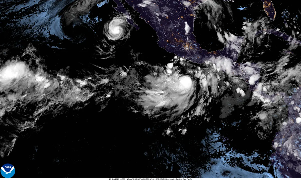
Category 3 Hurricane Polo aims at Baja California Sur for Monday landfall
Polo remained a Category 3 hurricane with 115 mph winds early Monday about 110 miles southwest of Cabo San Lázaro, the National Hurricane Center said at 5 a.m. MST. It is forecast to move inland over Baja California Sur late Monday afternoon or early evening and into southern Sonora late Monday night or early Tuesday. Rain of 6–12 inches threatens life-threatening floods and mudslides in Baja; remnant moisture may fuel U.S. Southwest flash flooding.
AI-assisted · US Brief desk · Sources listed below
What happened
Hurricane Polo remained a major Category 3 storm early Monday and was forecast to strike Baja California Sur late Monday before crossing into northwestern mainland Mexico, raising the risk of life-threatening floods and mudslides along a busy tourist corridor and sending moisture toward the U.S. Southwest.
Where the storm is: The National Hurricane Center's Intermediate Advisory 31A (5:00 a.m. MST Monday) put Polo's center near 23.9°N, 113.7°W — about 110 miles southwest of Cabo San Lázaro and 250 miles south-southwest of Santa Rosalía — with maximum sustained winds of 115 mph and a central pressure of 958 mb, down from 125 mph in Sunday evening's advisory. The hurricane was moving north-northeast near 10 mph and was expected to turn northeast Monday afternoon, move inland along the coast of Baja California Sur late Monday afternoon or early evening, and move inland in southern Sonora late Monday night or early Tuesday. NHC said Polo was forecast to be near major-hurricane strength when it reaches Baja California Sur and still a hurricane at mainland landfall; hurricane-force winds extended up to 40 miles from the center.
Warnings and local impact: A Hurricane Warning covered the west coast of Baja California Sur from Punta Abreojos to Santa Fe, the east coast from Loreto to Bahía San Juan Bautista (upgraded from a watch north of Santa Rosalía in Advisory 31 at 2 a.m. MST Monday), and mainland Mexico from Bahía Kino to Huatabampito. Hurricane and tropical-storm watches/warnings also covered adjoining Baja and Sonora/Sinaloa stretches. NHC expected tropical-storm conditions to begin in the southern Baja warning area Monday morning and hurricane conditions along the west coast by late Monday afternoon. Baja California Sur's Civil Protection Council suspended classes through Tuesday, Sep 29, halted maritime activities, and designated 169 temporary shelters with capacity for about 33,000 people, The Watchers reported from state statements. Reuters said heavy rain, high surf, and strong winds had already prompted evacuations, port closures, and beach restrictions in places such as San José del Cabo.
Why it matters
A landfalling major hurricane on the Baja peninsula threatens tourists and residents around Los Cabos and sparsely populated central Baja communities alike, while a second hit on Sonora raises flood risks for northern Mexico. For the United States, the story is less about a Gulf Coast-style landfall and more about whether Polo's inland moisture becomes a flash-flood maker across drought-sensitive Southwest watersheds early in the workweek.
What’s next
Watch Monday's Baja landfall intensity, whether mainland Mexico hurricane warnings are expanded, rainfall totals versus the 12-inch local maxima, and Weather Prediction Center flash-flood outlooks for Arizona, New Mexico, and West Texas as remnant moisture arrives.
More context
Rain and U.S. knock-on risk: NHC forecast 6 to 12 inches of rain across portions of Baja California Sur, and 4 to 6 inches (locally near 8) in parts of Sonora — enough for life-threatening flooding and mudslides in steep terrain, plus storm surge and destructive waves on exposed coasts. Polo is not forecast to reach the southern United States as a tropical cyclone, but Yale Climate Connections, citing the NOAA/NWS Weather Prediction Center, said remnant moisture from Polo (with leftover moisture from former Hurricane Odalys) could help produce multi-day rains and a moderate flash-flood risk across the Four Corners on Monday and from southeast Arizona toward the Texas Panhandle on Tuesday.
Caveats: Intensity and forward speed remain uncertain after Polo turns northeast and interacts with Baja's terrain; some private forecasts have called for faster weakening than NHC's official package. Shelter, outage, and evacuation counts will shift hour to hour. Confirm the latest track, watches, and road status against NHC and Mexican civil-protection updates.
8 listed sources
- National Hurricane Center, Hurricane Polo Intermediate Advisory #31A, 5:00 a.m. MST Sep 28, 2026
- National Hurricane Center, Hurricane Polo Public Advisory #31, 2:00 a.m. MST Sep 28, 2026
- National Hurricane Center, Hurricane Polo Public Advisory #30, 8:00 p.m. MST Sep 27, 2026
- NHC archive Advisory #27 (context on earlier watch expansions), Sep 27, 2026
- Reuters (Emily Green), Sep 27, 2026 — Category 3 Hurricane Polo threatens Mexico's coast; landfall expected Monday
- Yale Climate Connections (Bob Henson), Sep 27, 2026 — Polo approaches Mexico; Southwest moisture and WPC flash-flood risk
- The Watchers (citing NHC Adv. #27 and Baja California Sur Civil Protection), Sep 27, 2026 — shelters, class suspensions, maritime halt
- U.S. Embassy & Consulates in Mexico weather alert (updated context), Sep 24–27, 2026 — Baja Peninsula and Sonora in storm's path
References listed by US Brief; a source count is not a verification score.
Editorial sourcing notes
Intensity, position, motion, watches/warnings, and rainfall forecasts follow NHC Hurricane Polo Intermediate Advisory 31A (5:00 a.m. MST / 1200 UTC Sep 28, 2026), with the east-coast warning upgrade from Advisory 31 (2:00 a.m. MST); the prior 125 mph figure is from Advisory 30 (8:00 p.m. MST Sep 27). Mexico civil-protection measures (school/government suspensions through Sep 29, shelter inventory, maritime halt) follow The Watchers summary of Baja California Sur government statements, Sep 27, 2026. U.S. Southwest moisture/flash-flood risk follows Yale Climate Connections (Bob Henson) citing NOAA/NWS Weather Prediction Center, Sep 27, 2026. Reuters (Emily Green), Sep 27, supplies tourist-area impact context. AccuWeather's weaker landfall call in some wire wraps conflicts with NHC's official forecast that Polo may still be near major-hurricane strength at Baja — we follow NHC. Track and intensity can change; confirm against the latest NHC advisory.
Like US Brief? You can support it with a tip.